get nearest points between pairs of geometries
Usage
st_nearest_points(x, y, ..., by_element = FALSE)

# S3 method for class 'sfc'
st_nearest_points(x, y, ..., pairwise = by_element, by_element = FALSE)

# S3 method for class 'sfg'
st_nearest_points(x, y, ...)

# S3 method for class 'sf'
st_nearest_points(x, y, ...)
Arguments
- x
object of class
sfg,sfcorsf- y
object of class
sfg,sfcorsf; needs to have the same number of geometries ofxwhenby_element=TRUE- ...
ignored
- by_element
logical; if
FALSE(default) return nearest points between all possible pairs, ifTRUE, return nearest points between row-wise x-y pairs.- pairwise
logical; deprecated in favour of
by_element
Value
an sfc object with all two-point LINESTRING geometries of point pairs from the first to the second geometry, of length x * y if by_element=FALSE (with y cycling fastest), or lf length length(x) when by_element=TRUE. See examples for ideas how to convert these to POINT geometries.
Details
in case x lies inside y, when using S2, the end points
are on polygon boundaries, when using GEOS the end point are identical to x.
See also
st_nearest_feature for finding the nearest feature
Examples
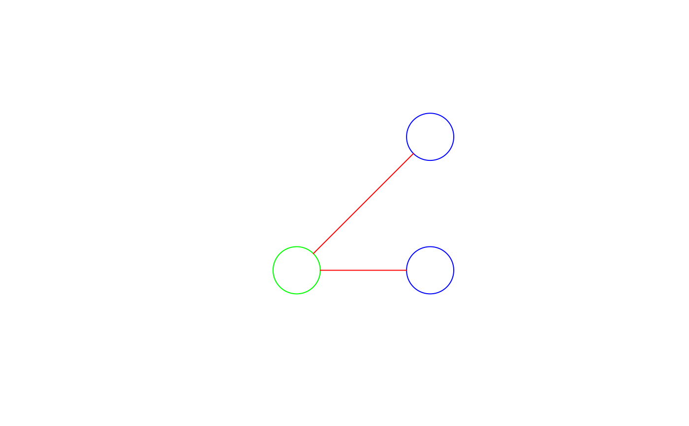
r = sqrt(2)/10
pt1 = st_point(c(.1,.1))
pt2 = st_point(c(.9,.9))
pt3 = st_point(c(.9,.1))
b1 = st_buffer(pt1, r)
b2 = st_buffer(pt2, r)
b3 = st_buffer(pt3, r)
(ls0 = st_nearest_points(b1, b2)) # sfg
#> Geometry set for 1 feature
#> Geometry type: LINESTRING
#> Dimension: XY
#> Bounding box: xmin: 0.2 ymin: 0.2 xmax: 0.8 ymax: 0.8
#> CRS: NA
#> LINESTRING (0.2 0.2, 0.8 0.8)
(ls = st_nearest_points(st_sfc(b1), st_sfc(b2, b3))) # sfc
#> Geometry set for 2 features
#> Geometry type: LINESTRING
#> Dimension: XY
#> Bounding box: xmin: 0.2 ymin: 0.1 xmax: 0.8 ymax: 0.8
#> CRS: NA
#> LINESTRING (0.2 0.2, 0.8 0.8)
#> LINESTRING (0.2414214 0.1, 0.7585786 0.1)
plot(b1, xlim = c(-.2,1.2), ylim = c(-.2,1.2), col = NA, border = 'green')
plot(st_sfc(b2, b3), add = TRUE, col = NA, border = 'blue')
plot(ls, add = TRUE, col = 'red')
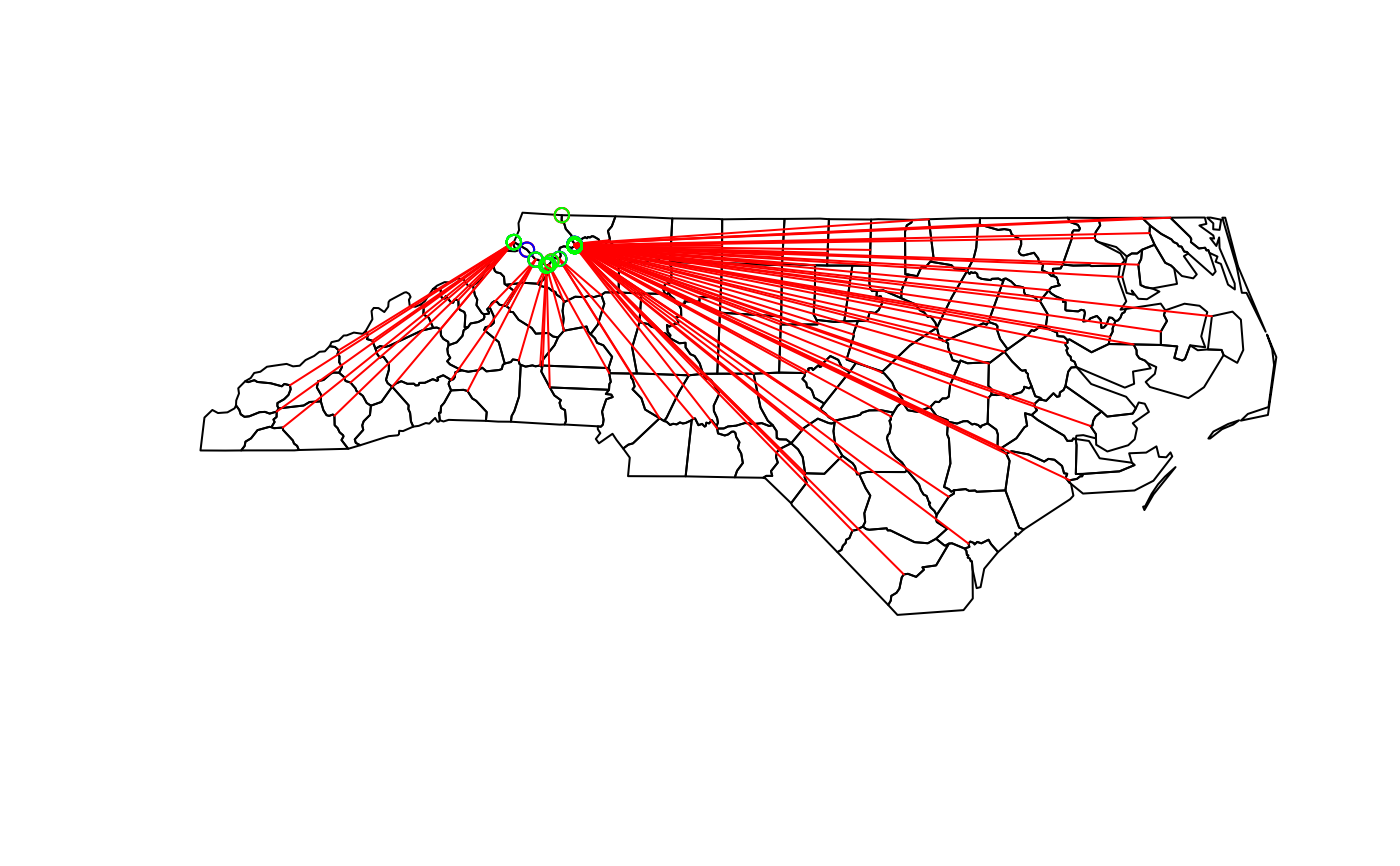
 nc = st_read(system.file("gpkg/nc.gpkg", package="sf"))
#> Reading layer `nc.gpkg' from data source
#> `/home/runner/work/_temp/Library/sf/gpkg/nc.gpkg' using driver `GPKG'
#> Simple feature collection with 100 features and 14 fields
#> Geometry type: MULTIPOLYGON
#> Dimension: XY
#> Bounding box: xmin: -84.32385 ymin: 33.88199 xmax: -75.45698 ymax: 36.58965
#> Geodetic CRS: NAD27
plot(st_geometry(nc))
ls = st_nearest_points(nc[1,], nc)
plot(ls, col = 'red', add = TRUE)
pts = st_cast(ls, "POINT") # gives all start & end points
#> Warning: point from first coordinate only
#> Warning: point from first coordinate only
#> Warning: point from first coordinate only
#> Warning: point from first coordinate only
#> Warning: point from first coordinate only
#> Warning: point from first coordinate only
#> Warning: point from first coordinate only
#> Warning: point from first coordinate only
#> Warning: point from first coordinate only
#> Warning: point from first coordinate only
#> Warning: point from first coordinate only
#> Warning: point from first coordinate only
#> Warning: point from first coordinate only
#> Warning: point from first coordinate only
#> Warning: point from first coordinate only
#> Warning: point from first coordinate only
#> Warning: point from first coordinate only
#> Warning: point from first coordinate only
#> Warning: point from first coordinate only
#> Warning: point from first coordinate only
#> Warning: point from first coordinate only
#> Warning: point from first coordinate only
#> Warning: point from first coordinate only
#> Warning: point from first coordinate only
#> Warning: point from first coordinate only
#> Warning: point from first coordinate only
#> Warning: point from first coordinate only
#> Warning: point from first coordinate only
#> Warning: point from first coordinate only
#> Warning: point from first coordinate only
#> Warning: point from first coordinate only
#> Warning: point from first coordinate only
#> Warning: point from first coordinate only
#> Warning: point from first coordinate only
#> Warning: point from first coordinate only
#> Warning: point from first coordinate only
#> Warning: point from first coordinate only
#> Warning: point from first coordinate only
#> Warning: point from first coordinate only
#> Warning: point from first coordinate only
#> Warning: point from first coordinate only
#> Warning: point from first coordinate only
#> Warning: point from first coordinate only
#> Warning: point from first coordinate only
#> Warning: point from first coordinate only
#> Warning: point from first coordinate only
#> Warning: point from first coordinate only
#> Warning: point from first coordinate only
#> Warning: point from first coordinate only
#> Warning: point from first coordinate only
#> Warning: point from first coordinate only
#> Warning: point from first coordinate only
#> Warning: point from first coordinate only
#> Warning: point from first coordinate only
#> Warning: point from first coordinate only
#> Warning: point from first coordinate only
#> Warning: point from first coordinate only
#> Warning: point from first coordinate only
#> Warning: point from first coordinate only
#> Warning: point from first coordinate only
#> Warning: point from first coordinate only
#> Warning: point from first coordinate only
#> Warning: point from first coordinate only
#> Warning: point from first coordinate only
#> Warning: point from first coordinate only
#> Warning: point from first coordinate only
#> Warning: point from first coordinate only
#> Warning: point from first coordinate only
#> Warning: point from first coordinate only
#> Warning: point from first coordinate only
#> Warning: point from first coordinate only
#> Warning: point from first coordinate only
#> Warning: point from first coordinate only
#> Warning: point from first coordinate only
#> Warning: point from first coordinate only
#> Warning: point from first coordinate only
#> Warning: point from first coordinate only
#> Warning: point from first coordinate only
#> Warning: point from first coordinate only
#> Warning: point from first coordinate only
#> Warning: point from first coordinate only
#> Warning: point from first coordinate only
#> Warning: point from first coordinate only
#> Warning: point from first coordinate only
#> Warning: point from first coordinate only
#> Warning: point from first coordinate only
#> Warning: point from first coordinate only
#> Warning: point from first coordinate only
#> Warning: point from first coordinate only
#> Warning: point from first coordinate only
#> Warning: point from first coordinate only
#> Warning: point from first coordinate only
#> Warning: point from first coordinate only
#> Warning: point from first coordinate only
#> Warning: point from first coordinate only
#> Warning: point from first coordinate only
#> Warning: point from first coordinate only
#> Warning: point from first coordinate only
#> Warning: point from first coordinate only
#> Warning: point from first coordinate only
# starting, "from" points, corresponding to x:
plot(pts[seq(1, 200, 2)], add = TRUE, col = 'blue')
# ending, "to" points, corresponding to y:
plot(pts[seq(2, 200, 2)], add = TRUE, col = 'green')
nc = st_read(system.file("gpkg/nc.gpkg", package="sf"))
#> Reading layer `nc.gpkg' from data source
#> `/home/runner/work/_temp/Library/sf/gpkg/nc.gpkg' using driver `GPKG'
#> Simple feature collection with 100 features and 14 fields
#> Geometry type: MULTIPOLYGON
#> Dimension: XY
#> Bounding box: xmin: -84.32385 ymin: 33.88199 xmax: -75.45698 ymax: 36.58965
#> Geodetic CRS: NAD27
plot(st_geometry(nc))
ls = st_nearest_points(nc[1,], nc)
plot(ls, col = 'red', add = TRUE)
pts = st_cast(ls, "POINT") # gives all start & end points
#> Warning: point from first coordinate only
#> Warning: point from first coordinate only
#> Warning: point from first coordinate only
#> Warning: point from first coordinate only
#> Warning: point from first coordinate only
#> Warning: point from first coordinate only
#> Warning: point from first coordinate only
#> Warning: point from first coordinate only
#> Warning: point from first coordinate only
#> Warning: point from first coordinate only
#> Warning: point from first coordinate only
#> Warning: point from first coordinate only
#> Warning: point from first coordinate only
#> Warning: point from first coordinate only
#> Warning: point from first coordinate only
#> Warning: point from first coordinate only
#> Warning: point from first coordinate only
#> Warning: point from first coordinate only
#> Warning: point from first coordinate only
#> Warning: point from first coordinate only
#> Warning: point from first coordinate only
#> Warning: point from first coordinate only
#> Warning: point from first coordinate only
#> Warning: point from first coordinate only
#> Warning: point from first coordinate only
#> Warning: point from first coordinate only
#> Warning: point from first coordinate only
#> Warning: point from first coordinate only
#> Warning: point from first coordinate only
#> Warning: point from first coordinate only
#> Warning: point from first coordinate only
#> Warning: point from first coordinate only
#> Warning: point from first coordinate only
#> Warning: point from first coordinate only
#> Warning: point from first coordinate only
#> Warning: point from first coordinate only
#> Warning: point from first coordinate only
#> Warning: point from first coordinate only
#> Warning: point from first coordinate only
#> Warning: point from first coordinate only
#> Warning: point from first coordinate only
#> Warning: point from first coordinate only
#> Warning: point from first coordinate only
#> Warning: point from first coordinate only
#> Warning: point from first coordinate only
#> Warning: point from first coordinate only
#> Warning: point from first coordinate only
#> Warning: point from first coordinate only
#> Warning: point from first coordinate only
#> Warning: point from first coordinate only
#> Warning: point from first coordinate only
#> Warning: point from first coordinate only
#> Warning: point from first coordinate only
#> Warning: point from first coordinate only
#> Warning: point from first coordinate only
#> Warning: point from first coordinate only
#> Warning: point from first coordinate only
#> Warning: point from first coordinate only
#> Warning: point from first coordinate only
#> Warning: point from first coordinate only
#> Warning: point from first coordinate only
#> Warning: point from first coordinate only
#> Warning: point from first coordinate only
#> Warning: point from first coordinate only
#> Warning: point from first coordinate only
#> Warning: point from first coordinate only
#> Warning: point from first coordinate only
#> Warning: point from first coordinate only
#> Warning: point from first coordinate only
#> Warning: point from first coordinate only
#> Warning: point from first coordinate only
#> Warning: point from first coordinate only
#> Warning: point from first coordinate only
#> Warning: point from first coordinate only
#> Warning: point from first coordinate only
#> Warning: point from first coordinate only
#> Warning: point from first coordinate only
#> Warning: point from first coordinate only
#> Warning: point from first coordinate only
#> Warning: point from first coordinate only
#> Warning: point from first coordinate only
#> Warning: point from first coordinate only
#> Warning: point from first coordinate only
#> Warning: point from first coordinate only
#> Warning: point from first coordinate only
#> Warning: point from first coordinate only
#> Warning: point from first coordinate only
#> Warning: point from first coordinate only
#> Warning: point from first coordinate only
#> Warning: point from first coordinate only
#> Warning: point from first coordinate only
#> Warning: point from first coordinate only
#> Warning: point from first coordinate only
#> Warning: point from first coordinate only
#> Warning: point from first coordinate only
#> Warning: point from first coordinate only
#> Warning: point from first coordinate only
#> Warning: point from first coordinate only
#> Warning: point from first coordinate only
#> Warning: point from first coordinate only
# starting, "from" points, corresponding to x:
plot(pts[seq(1, 200, 2)], add = TRUE, col = 'blue')
# ending, "to" points, corresponding to y:
plot(pts[seq(2, 200, 2)], add = TRUE, col = 'green')